
南厦高速路基路面综合设计K53+200-K54+600(含CAD图)

南厦高速路基路面综合设计K53+200-K54+600(含CAD图)(论文计算书17000字,CAD图13张)
摘 要
本设计为南厦高速路基路面综合设计。设计车速100km/h,路基宽33.5m,公路汽车设计荷载采用公路-I级,设计路线全长1.4公里。
本设计包括路线的纵断面、横断面、边坡防护与加固、排水系统、涵洞、水泥混凝土路面设计、沥青混凝土路面设计。纵断面设计是根据道路等级、沿线自然条件和构造物控制标高等,确定路线合适的标高、各坡段的纵坡度和坡长,并设计竖曲线。横断面设计是根据设计资料说明,并参照“标准横断面图”,画出路幅宽度,填或挖的边坡线,在需要设置各种支挡工程和防护工程的地方画出该工程结构的断面示意图。边坡防护与加固设计是根据边坡的高度,路基横断面形式进行植草或圬工防护。排水系统设计是根据横断面沟底标高确定流水方向,并设置涵洞。路面设计是根据公路等级、交通量进行路面结构设计。施工组织设计是根据沿线路段自然条件和工程量来确定施工进度和布置施工总平面图。
关键词:高速公路、路基、路面、排水、防护
ABSTRACT
The highway of Shangzhou to Shanyujie and Zhangxiang country to Koqian sectional design
(K53+200-K54+600)
ABSTRACT:This design is the highway of Shangzhou to Shanyujie and Zhangxiang country to Koqian sectional design. Design speed is 100km/h, subgrade width is 26 M, highway vehicle design load by road-I level, the total length of this highway is 1.4 kilometers.
The design includ the vertical section cross-sectional of the line design, slope protection and reinforcement, drainage systems, the culvert road design and the construction organization design . The profile design is based on grade of the road, the natural conditions and structures control elevation to determine the appropriate elevation of the road, the different slope of the vertical slope and the slope length and design of vertical curve. The main content of cross-sectional design is based on design information, in the light of the "standard cross-sectional map", drawing a way width, filling or digging slope of the slope, the need to set all kinds of support Engineering and protection engineering block where to draw the project structure of the cross-section diagram. Slope protection and reinforcement design is based on the height of the slope, cross-sectional form of grass embankment or masonry protection. Drainage system design is based on cross-sectional elevation of the ditch to determine the direction of flow, and set the culvert. Cement concrete pavement design is based on road grade, traffic volume pavement structure design. Construction design is based on the natural conditions along the roads and the construction quantities to determine the layout of the construction progress and the overall plan.
Keywords : Highway;Subgrade;Pavement;Drainage;Protection
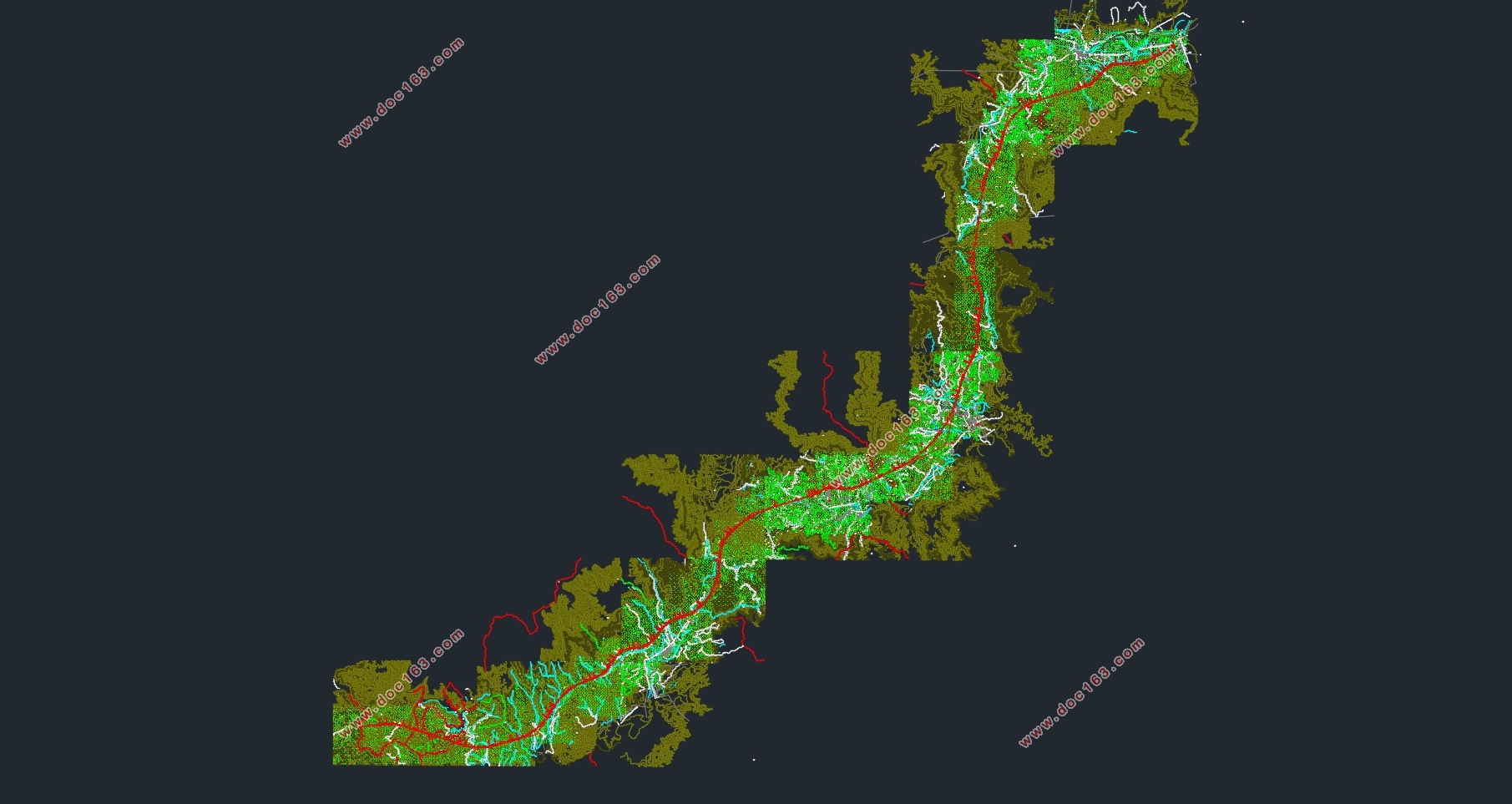
本项目地处泉州西南部和厦门北部,沿线属闽南丘陵区,地形由山岭、丘陵、河谷、台地及山间小盆地组成,地形起伏大。总地势为北部高,往南呈阶梯状降低。穿越的地貌单元有侵蚀剥蚀形成的丘陵地地貌、河谷阶地、山间凹地等。河谷阶地多分布于西溪、兰溪两岸,地形起伏较小,在凸岸多以堆积作用为主、在凹岸多为侵蚀作用为主。
气候状况:项目区地处沿海,属亚热带海洋气候区,气候温和湿润,年平均气温21℃左右,最底气温在一月份,最高气温在七月份,年平均降雨量1782毫米。降雨分布不均,年际变化大。风向夏季多为东南偏南风,东季多为偏东风,台风多发于5~10月,主要集中在7~9月,中心最大风力达12级以上。
项目区境内植被发育,局部基岩裸露。水系发育,溪流密布,有兰溪、西溪、龙门溪、澳溪等,呈树状水系分布。地表径流常年不断,自然蓄水能力较强,水力、水电资源丰富。
地震情况:依据《中国地震动参数区划图》(GB18306-2001),本项目沿线地震烈度7度区,设计地震动峰加速度值为0.10g,中硬场地的地震动反应谱特征周期值为0.45s。
1.2 主要技术指标
1.2.1公路等级:高速公路; [版权所有:http://DOC163.com]
1.2.2设计速度:100km/h;
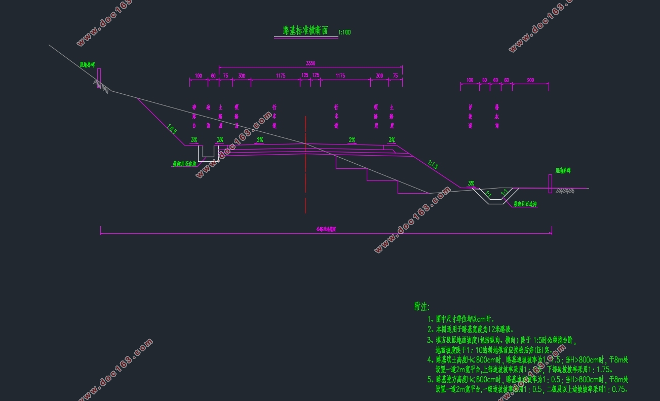
1.2.3路基宽度:双向六车道,宽33.5m;
1.2.4采用的路面方案:
1.2.4.1水泥混凝土路面,设计年限X年;
1.2.4.2沥青混凝土路面,设计年限Y年。
1.2.5道路的使用性质和交通量:
1.2.5.1水泥混凝土路面段基准期内设计车道标准轴载的作用次数 为:10741724,属于重交通等级;
1.2.5.2沥青混凝土路面段基准期内设计车道标准轴载的作用次数 为:12987651,属于重交通等级;
1.2.6路线设计起始点及设计高程:
起点桩号:K53+200 设计高程:650.0m
终点桩号:K54+600 设计高程:671.1m
2.路线平面设计说明
2.1 技术标准
2.1.1.圆曲线半径1400m;
2.1.2.缓和曲线长100m;
2.2 本路段平面设计
[来源:http://www.doc163.com]
目录
摘 要 3 [资料来源:http://Doc163.com]
ABSTRACT 4
目录 5
绪论 6
1.综合情况概述 6
2.路线平面设计说明 7
3.路线纵断面设计说明 8
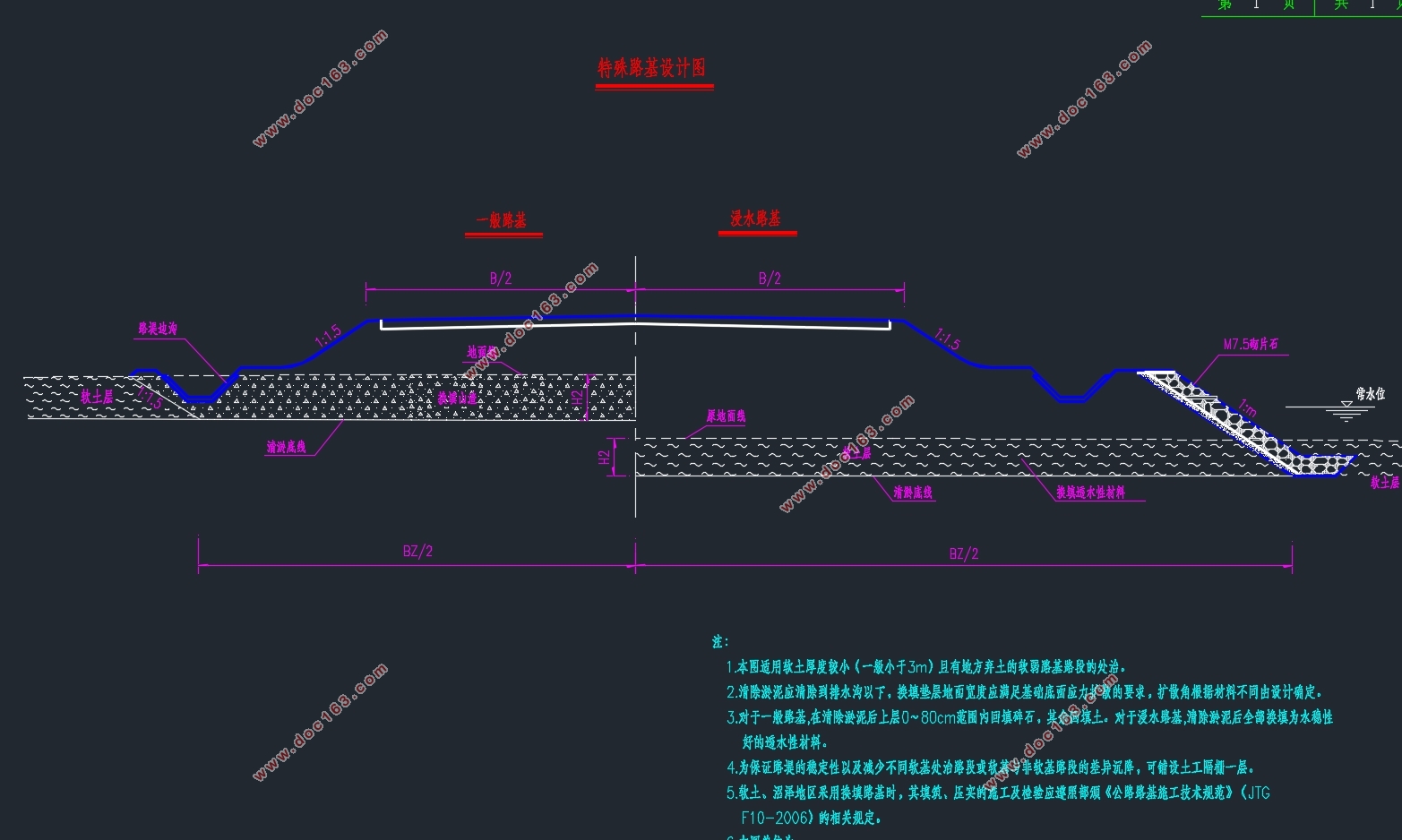
4.路基横断面设计说明 10
5.排水设计说明 12
6.涵洞设计说明 13
7.挡土墙设计说明 16
8.边坡稳定分析 23
9.路面设计说明 25
结论 41
参考文献 42
致谢 43
[资料来源:Doc163.com]