基于GIS的城市轨道交通规划对周边房地产的影响研究-以某市为例
基于GIS的城市轨道交通规划对周边房地产的影响研究-以某市轨道交通线为例(7300字)
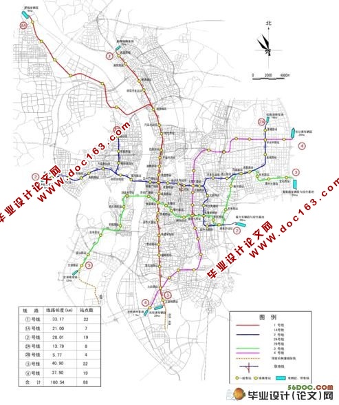
摘 要:本文以长沙市轨道交通2号主干线及其两条支线为例,在MAPGIS软件的空间分析子系统中,对全线1000m范围内做不同程度的缓冲区分析,对叠加分析得到的各层次缓冲区内楼盘数据,通过属性统计和对比分析,结果表明城市轨道交通建设对周边房地产价值有明显的增值效应,其影响半径为500m,尤以300-500m范围内房地产的开发程度影响较大。最后针对城市轨道交通2号线未来的土地利用和房地产联合开发提出一些建议。
关键词:城市轨道交通;GIS;缓冲区分析;叠加分析;房地产价格;联合开发;
Impacts of urban rail transit plan on property values based on GIS:
A case study of 2nd URRT in Changsha city
Abstract: The paper is to analyze the 2nd URRT in Changsha city and its two branch lines and make buffer analyses which are in different degree of 1000m distance using spatial analysis in MAPGIS. Then, the result indicates that the construction of Urban Railway Transport has obvious effects on the value of surrounding real-estate by conducting attributes statistics and comparative analysis on those data obtained through overlay analysis in all levels buffer area. Its influence radius is 500m and the estate developing degree within 300m to 500m is under the biggest influence. Finally, this paper offers some suggestions for the land utilization of 2nd URRT in the future and the estate joint development.
Key words: Urban Rapid Rail Transit; Geographic Information System; Buffer analysis; Overlay analysis; Real estate price; Joint development; [来源:http://www.doc163.com]
[来源:http://Doc163.com]